Best Google Maps alternatives for planning a trip with friends (2026)
Updated July 11, 2026
Google Maps is where you navigate, and it is hard to beat for that. Turn-by-turn directions, live traffic, transit times, street view: for getting from one place to the next, it is the standard everything else is measured against. The problem is not navigation. It is the moment you try to plan a trip together on it, when the cracks show almost immediately.
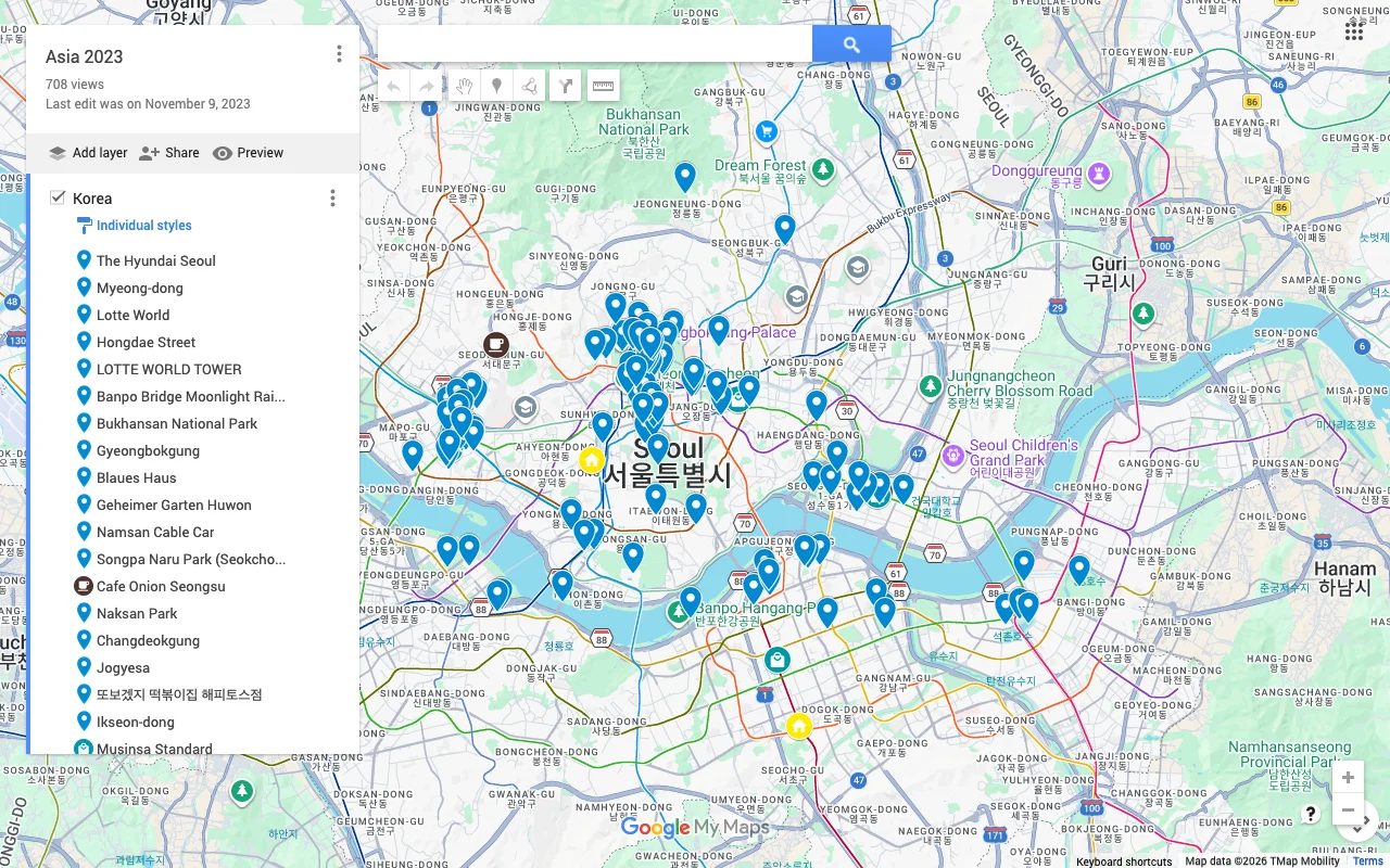
The two obvious tools inside Google Maps both fall short in different ways. Saved lists are not truly collaborative, so sharing one to plan with friends tends to be glitchy and one-directional. My Maps is more capable but only edits on a desktop, which is useless in the exact situation where you find most of your places: out in the world, on your phone. So people end up screenshotting lists back and forth, pasting links into a group chat, and slowly losing track of who suggested what.
If that is your sticking point, here are the best alternatives for a shared, editable trip map in 2026, and who each one is for. They are ranked roughly by how well they cover collaborative planning, but each has a specific job it does best, so read for the fit.
What makes a good shared trip map
Before comparing tools, it helps to know what actually separates a real planning map from a glorified list of pins. The gap between Google Maps and a purpose-built planner comes down to a handful of things, and weighing them against your own trip tells you which alternative fits.
- Live editing on every device, so the whole group can add and rearrange places from their phones at the same time, not one person at a desk while everyone else waits.
- A way to decide, not just collect, meaning voting or some signal of what the group actually wants, so a pile of saved spots turns into a plan.
- Fast, low-friction adding, ideally paste-a-link import from TikTok, Reels, or articles, so gathering ideas does not mean retyping every address.
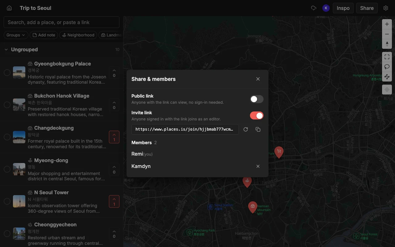
- Sensible sharing, a link anyone can open plus the option to invite editors, without collaborators getting silently trapped in read-only.
Hold those four up against how your group plans. If everyone contributes from their phone and ideas arrive as social videos, the tools that nail live editing and import rise to the top; if you only need a private list for yourself, the bar is far lower.
First, the two Google tools and their limits
Most people who say “Google Maps for planning” actually mean one of two different Google products, and each falls short in its own way, so it is worth separating them before comparing anything else.
Google Maps lists let you save and share places, which sounds like collaboration but is not really. Editing together is glitchy and not real-time, so invitees often end up stuck in a read-only view even when you meant to give them edit access, and there is no voting to actually settle where the group wants to go. Google also removed public list sharing back in November 2023, and even now you cannot copy or search a list, only follow one, which quietly kills a lot of the ways people want to reuse and remix each other’s plans.
Google My Maps is the more capable of the two: several people can genuinely edit one custom map, with layers and styled pins, which saved lists do not really allow. But it is not live, so everyone has to refresh to see each other’s changes, and the bigger catch is that it is only editable on a computer, so you cannot edit it from your phone. That is a fatal limitation for trip planning, because the moment you stumble on a cafe worth saving or want to reshuffle tomorrow while you are out, you do not have a laptop open. A planning map you can only edit at a desk is a planning map you will not keep up to date.
Places, best for a live shared map on any device
Places is the closest thing to “Google Maps, but built for planning together.” Everyone edits the same map in real time on the web, iPhone, and Android, so the person on the couch and the person on the train see the same map update as it changes, with none of the screenshot relay that Google forces. You can share a read-only link that anyone opens without an account, or invite specific people to edit, so the sharing model actually matches how a group works.
It also fixes the deciding, not just the saving. You can vote on spots so the group settles on a plan inside the app instead of in a scattered chat, and you can add notes and colours to each place to mark a must-do from a maybe and record why it is on the map at all. Because it stays fast as the map fills up, a trip with a lot of pins does not slow to a crawl, which matters once a few people have each added their finds.
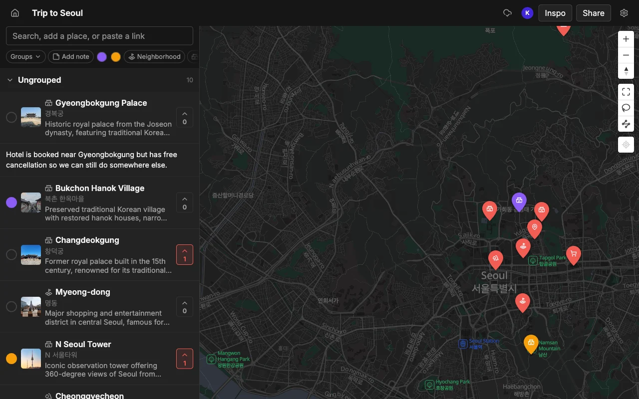
Getting places onto it is fast, too. Paste a TikTok, a Reel, a YouTube video, or a travel article and it pins each spot automatically, complete with a photo and a short description, so you are not searching for every address by hand the way Google Maps lists make you. It is free to start, with unlimited maps, places, and collaborators. When the plan is done, you can export it to KML, CSV, or PDF. Best for planning a trip together and deciding where to go. Here is how it compares to Google Maps lists.
Wanderlog, best for a full day-by-day itinerary
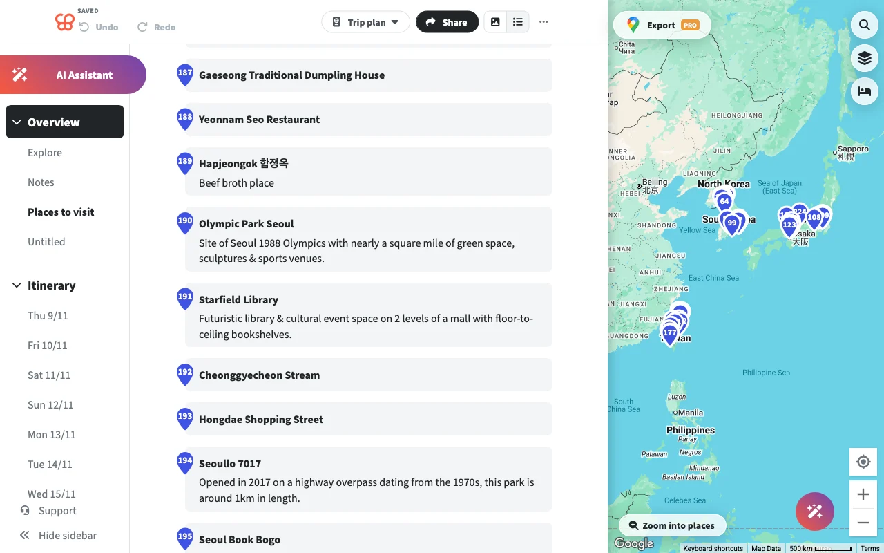
Wanderlog takes a different angle: instead of a loose map, it builds a structured day-by-day itinerary with flights, hotels, and driving times, and collaboration is built in. If your trip is heavy on logistics, with reservations to track and drive segments to time, it does a thorough job of laying the whole thing out day by day, and having the bookings and the route in one timeline is useful.
The trade-offs are worth knowing before you commit. It can slow down on large trips, reportedly because it reloads place photos on every launch, so a big itinerary can feel sluggish. It also does not import from social videos, so those TikTok and Reel finds go in by hand, and its map fills only half the screen, which frustrates people who plan by geography. None of that undoes its strength at logistics, but it does make it a better fit for structured trips than for the loose, idea-gathering early stage. Best for trips that are mostly logistics.
Mapstr, best for saving and following spots
Mapstr is good for a personal library of places and for following the maps of friends and tastemakers whose recommendations you trust. As a way to build up a lasting record of spots you love, tagged and pinned over years, it works well, and the follow network makes it easy to pick up ideas from people whose taste you rate.
Where it falls short for group trip planning is collaboration and import. Its shared maps are add-only, so people can drop pins but cannot fully edit together the way a live trip plan needs, and it has no social-video import, so those link finds are added manually. It ends up being more of a place journal than a group planner, best maintained by one person over the long haul rather than co-owned by a group for a single trip. Best for saving over time rather than planning one trip.
When to still use Google Maps
None of this means dropping Google Maps. It is still the right tool for the part it does best, which is navigation, and no alternative here is trying to replace turn-by-turn directions. The smart move is to split the work by what each tool does well rather than forcing one app to do everything.
Once the plan is set, export your Places map to KML and open it directly in Google Maps for turn-by-turn directions on the day. That way the deciding happens in a tool actually built for a group, and the driving happens in the tool built for driving, with your chosen places carried across between them. The natural split is simple: use Places to decide together, then use Google Maps to actually get there.
Frequently asked questions
- Can several people edit a Google Maps list at once?
- They can be invited, but editing is unreliable and not live, so collaborators frequently land in a read-only view and changes do not sync the way a group needs. There is more on why here.
- Why can't I edit My Maps on my phone?
- My Maps editing is desktop only, a long-standing limitation covered here. You can view a My Map on your phone, but the actual editing tools only work on a computer, which is why it is awkward for on-the-go planning.
- What happened to public Google Maps lists?
- Google removed public list sharing in November 2023, and you still cannot copy or search a list, only follow one. That closed off a lot of the ways people used to share and reuse each other's saved places.
- Is there a free alternative that works on my phone?
- Yes. Places is free to start on the web, iPhone, and Android, with unlimited maps, places, and collaborators, and it is editable live on every device rather than desktop only.
- Which alternative is best for a big group trip?
- A tool where everyone can edit live and vote will serve a group best, which is where Places fits. Wanderlog is stronger if the trip is mostly flights and hotels, and Mapstr is better for a personal collection than a shared plan.
- Can I still use Google Maps for directions after planning elsewhere?
- Yes. Export your Places map to KML and open it in Google Maps for navigation, so you plan together in one tool and drive with the other.